Sunday, September 28, 2014

Stehekin to Canada

TOTAL PCT MILES: 1851.3
PCT mile 2580 to PCT mile 2660
Section mileage: 110
Days: 9/23 - 9/28

Stehekin was like a storybook town, with one road that led from the trail to the dock. It is isolated, in space and communication from the outside world. To get to Stehekin, you need to take a ferry across a big lake or hike in like us. The lake is framed with mountains and fog. There is no cell phone or landline phone service. No internet. Just a community garden, an inn, and the most incredible bakery in the world. The winter population is only 61 hardy souls.

We were determined to get in and out of the town in one day. Rain was forecast for the next couple of days, and we wanted to get a head start on it. Four hours later, we had managed to pick up our resupply package, shower, do laundry, paw through hiker boxes, charge our electronics, and eat more food.

We took the bus back to the bakery, where we each selected a few baked goods for the last section of the trail. Without outside communication, we decided to play a high speed matching card game intended for children. For hours. It was hugely entertaining. We took the last bus of the evening back to the trail. We hiked a few miles out and set up under a big tree, just as the rain began. This was sure, we knew, to be the start of a lot of rain.

The next morning, we slept in until after 9. Despite the rain, the morning wasn't so bad. We walked through the mist with occasional drizzle, but since we were hiking uphill we stayed warm. We ran into a big, eight person group taking a lunch break together. "What is that? Mountain hardware?" One of the hikers called to Craig jokingly. Craig is using a stylish, heavy duty trash bag as a pack cover. It's surprisingly effective.

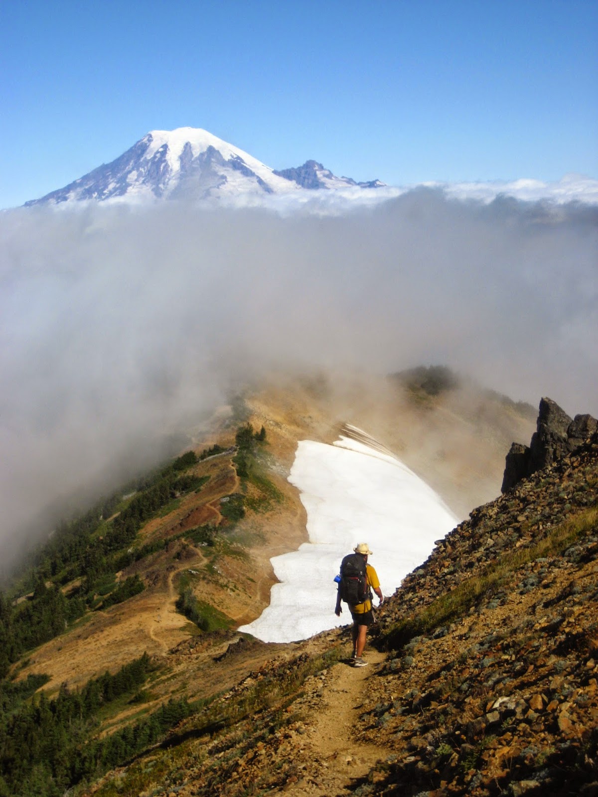
By Rainy Pass, it had really started to rain. "Why is this called Rainy Pass?" Said no-one, ever, in September. We continued climbing, but our arms were numb with cold. We warmed as we climbed higher, past tamarack trees with yellowing needles. Little rivulets of water ran across the trail. We found a little camping spot just shy of Cutthroat Pass 22 miles into our day. The clouds had blown past for a moment, so we took advantage of the break in the rain to set up our tent. We got a glimpse of the ridge and the jagged mountains south of us before zipping up the tarp to hide from the elements.

On the ridge, it was a cold night. We didn't start until 11 as it was freezing outside and still raining. Even in the tent, we could feel the chill of clouds blowing along the ridge. When we gathered the nerve to start, it was still cold and wet. Unfortunately, we were descending the mountain, so hiking didn't warm us much. By 3 in the afternoon, we had only gone 11 miles, but I was done hiking. We set up in the woods quickly. For the rest of the day, we read The Goldfinch aloud and made tea to warm up.

Since we bailed on the rain the day before, we had set ourselves up for a long day. We wanted to get close enough to the Canadian border so that we could slackpack ourselves there and back in a day. It was cloudy in the morning, but at least it wasn't raining again, and we had climb to warm us up. A couple times the sun blinked at us before the clouds swept through again. Long enough to give us a beautiful rainbow in the valley, but too brief for us to really dry out. Tall peaks were silhouetted behind the clouds. We descended to a completely abandoned Harts Pass, where we ate bagel sandwiches (thank you Stehekin bakery) for a chilly lunch.

Up we climbed into more misty, probably scenic mountains. We headlamped for about an hour to the top of a hill where we set up camp in a lumpy field. 31 miles. Tomorrow, to the border. To celebrate our long day and anticipated long day, I made double Teriyaki noodles with extra oil. It was cold and the ground was uneven, so I set up the stove in the middle of the tent. "Is that stable?" Craig asked nervously. "I think so," I responded. I reached to zip the tent and the pot toppled over, spilling greasy noodle water all over the inside of the tent and my sleeping pad. I almost started crying. Craig started giggling. "Not funny yet," I said. We used our bandanas to sop up the liquid, but it was still oily. Craig had the ingenious idea of using wet wipes to cut the grease. The great Teriyaki disaster of 2014.

The noodle grease attracted a whole colony of mice. All night we could hear them running around the tent and under it. We spotlighted one of them clinging to the mesh on the ceiling. It had beady little eyes and an adorable pointy nose. "Should we kill him?" Craig asked. Ever since he had woken to the mouse nibbling on his ear, Craig's been especially weary of mice. The mouse escaped the tent before we had to choose his fate. We duct taped the hole and went back to sleep. We had a big day ahead of us.

The next morning, we left camp at sunrise with the tent relatively mouse-proofed. The tent and grass were covered in a thick coat of frost. But! The sun was out and the sky was blue blue blue for the first time in (what felt like) forever! And it was my 30th birthday. We excitedly left camp, hiking in and out of the cold shade of the mountains. We hiked the long switchbacks up Woody Pass, passing thruhikers carrying their full loads. We stopped only once on the 15 miles to the border, to filter a liter of water. Craig presented me with a birthday present: the last Snickers bar. We continued to descend into the valley, to the anticlimactic border crossing in a shaded little clearing. There was a collection of little pillars marking the spot, and a couple of thruhikers taking photos. Glimmer and Coldstart, drinking little bottles of champagne. We split my last Stehekin baked good: a sticky bun, stale by now but still delicious, and a little box of wine, before turning around and retracing our steps back up the mountain.

We congratulated elated thruhikers as we passed them, heading for the border and the end of their hikes. By dusk, we were back at our tent. The mice had thankfully left it alone. Thirty miles for my thirtieth birthday. I could not think of a more fitting way to celebrate.

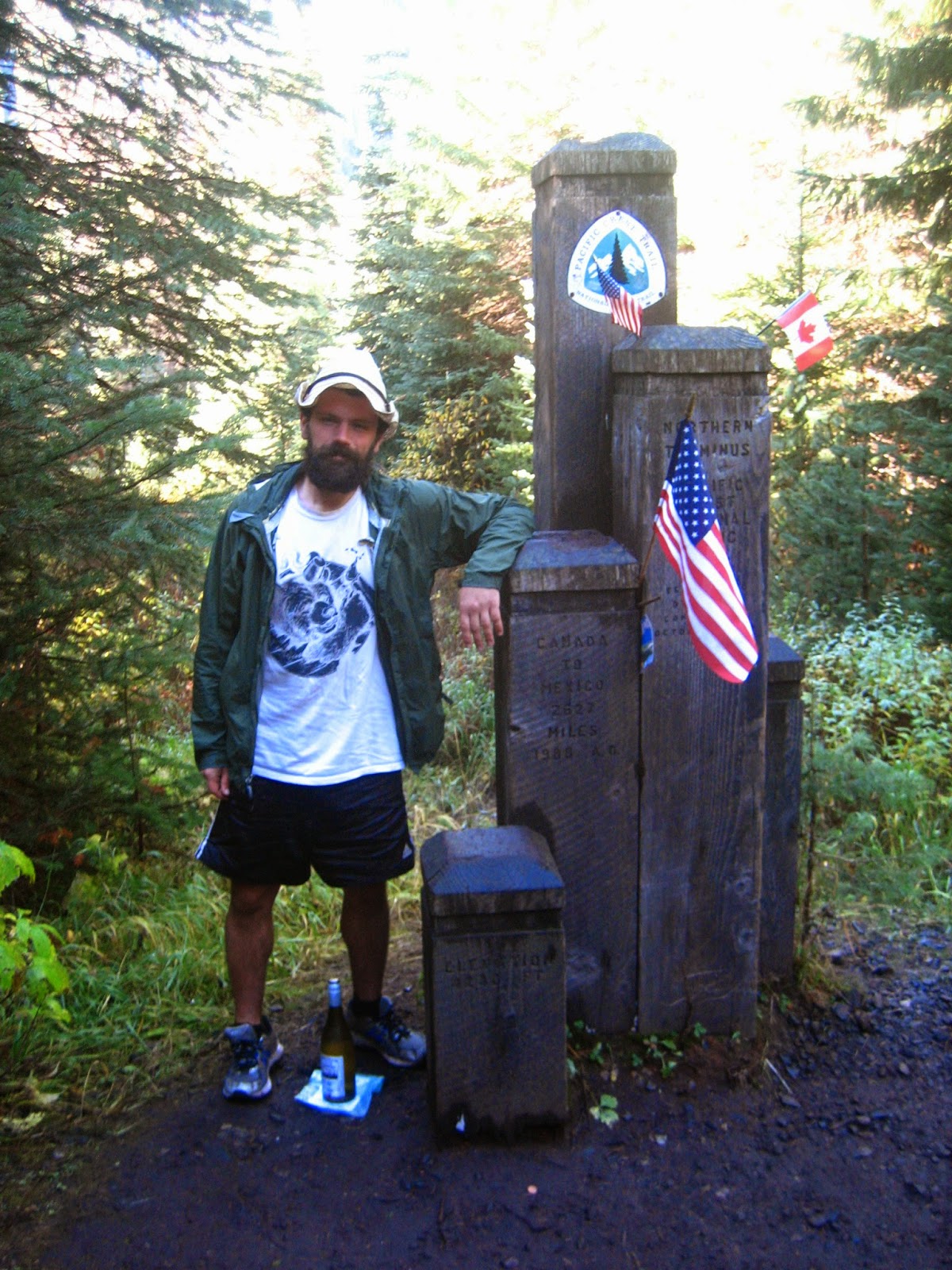
The next morning, we hiked the fifteen miles back to Harts Pass, where we hoped to find a ride down the mountain. We were thrilled when a young Polish couple picked us up. Down in the nearest outpost of Mazama, we crammed in sandwiches, beer, and chips until we could barely wobble to the highway to try our luck at hitching to Bellingham. We hadn't even reached the highway when a station wagon with a couple and their dog pulled off to offer a ride. And in a flash, this section of the trail was over.

Tuesday, September 23, 2014

Stevens Pass to Stehekin

PCT MILES COMPLETE: 1771.2
PCT mile 2476 to PCT mile 2580
Section mileage: 104
Days: 9/18 - 9/23

Before we left the resort, Craig asked one of the employees if there were any pizza places that delivered there. She said, "unfortunately, no. Wait here for a minute." Around the corner came another woman with a pizza. "Would you like a slice?" She asked, "we're testing our new pizza ovens today!" Saying goodbye to our new trail friends as they headed into Skykomish, we hiked a few more miles back into the foggy drizzle. We set up camp next to a little trickle of a stream before the rain really started in earnest again, watching TV (yes, TV) on my tablet until we were sleepy.

I woke up with a start to a girlish squeal in the middle of the night. "It was nibbling on my ear!" Craig said, "there was a mouse standing on my head, chewing on my ear." The mice kept us up again, scampering around outside the tent for the rest of the night. To our dismay, we woke late to more rainy mist.

At 10, we started hiking, feeling some regret that we had chosen to skip town. We climbed up and down over ridges, pikas calling back and forth in the mist. We saw no other backpackers all day. Maybe they were too smart to hike today, I thought gloomily. All of the views were socked in, and we can't wait for the mist to lift. We did run into another bear, once again eating berries. Once again, he lumbered off when he heard us approaching. We hiked until after dark, yet only managing to fit in 18 miles due to our late start. After last night's mouse trauma, we chose to hang the food on a nearby tree stop we could at least get a good night's sleep.

We were relieved to wake up the next morning to clear blue skies. The next couple days, the weather stayed sunny and the views were incredible as we approached Glacier Peak. The higher elevations were exposed and carpeted with ripe, sweet blueberries. Under the canopy, we collected edible oyster and lion's mane mushrooms, adding them to almost every meal. Our mileage climbed back into the 20s and spirits lifted as well. "I think this section is supposed to be the hardest in Washington," a hiker friend had told us at Stevens Pass. I hoped so. The days were filled with endless, long ascents and descents reminiscent of the Sierras. We ran into more hunters than thruhikers. At dusk, we ran into a sectionhiker we'd met back at White Pass before the wedding. We camped with him in a little clearing. The night was so warm and clear that we decided not to put our rain fly on.

I'm missing the fall colors in the northeast; they start now and peak in October. In this section, however, the colors have been amazing in their own way. The blueberry bushes are red and purple, other shrubs are turning yellow, and the evergreen conifers are, you know, green.

We woke up, predictably, to rain on our tarpless tent. It wasn't quite dawn, but we packed up quickly and started hiking. We were descending into a deep valley. In the distance, we could hear the rumbling of thunder. I counted the seconds between flashes of lightening and cracks of thunder; the storm was approaching. At last, we reached a grove of giant old growth trees, thick enough to provide cover from the rain. Silence. We filtered water, both unhappy with the rain. The stream at the bottom of the climb was a frothing torrent, milky white from glacial silt.

On the other side of the bridge, we began another huge climb into the clouds. We were running low on both food and fuel. At lunch, I ate cold mashed potatoes with crunchy mystery bits while Craig made the saddest burrito of all time: a tortilla with Taco Bell sauce and the rest of an Ez cheese can. We finally emerged into blueberry land with its adorable pikas and incredible colors.

Over the crest of the ridge, the misty views were replaced with an endless vista of naked, granitic mountains. We hiked in awe past a glacier and streams with just-melted ice cold water. Despite the beautiful views, I felt hungry and faint. As Craig filtered water in a glacier stream, I crunched on a dry packet of ramen noodles.

Twenty-nine miles into our day, we camped at dusk. Both of our feet killed. Mine were bleeding and Craig's felt like they were breaking. To compensate for our long, hard day, I made a massive pot of noodles for dinner.

We woke up at 5 am and hiked like mad to get to the ranger station before the first bus left at 9 am. Still in the dark, I saw Craig's light ahead stop and swing back and forth up the hill. I heard a small rustle and then silence. "What was that?" I asked. Craig's eyes were wide. "I think it was a mountain lion." Until it was light out, I felt unease, swinging my light behind me to look for the wideset eyes.

We arrived at the ranger station ten minutes early, where two other thruhikers were waiting, surprised to have us roll up from behind. The bus was driven by a friendly woman with minute braids. She stopped at the bakery long enough for us to run in and buy armloads of day-old balked goods. We happily crammed cookies and pie into our faces as the bus rolled into the magical town of Stehekin.


Thursday, September 18, 2014

Snoqualmie Pass to Stevens Pass

PCT MILES COMPLETE: 1667.2
PCT mile 2402 to PCT mile 2476
Section mileage: 74
Days: 9/15 - 9/18


Oyster mushrooms
We were both in rotten moods when we left the pass. We had decided to take an alternate route that would take us by Goldmyer Hot Springs and save us ten miles of hiking. Problem was, we didn't leave the pass until 4 pm, and our packs were loaded down with enough food for 170 miles. In my hand, I clutched a Ziploc bag with a carton of curry inside for dinner. It was muggy, and the alternate was steep. At the top of the climb, we skirted a lake and began the endless descent into the river valley. I lost count of switchbacks. Down we went, back and forth over boulder fields and still the river was too far away to hear. It got dark, and I was tired, and Craig was ahead. I could see his headlamp racing on the trail below.

I caught up at the bottom of the climb. He was talking to three hikers gathered around a campfire. "I don't think we're going to make it to the hot springs before they close," I told him. Another mile down the trail, we decided to set up camp for the night. We were disappointed to miss out on the springs, but at least we had curry for dinner.

Grilling chicken-of-the-woods
The next morning, we followed the river upstream through the humid, moss-choked valley. We collected edible chicken-of-the-woods and oyster mushrooms. Two of the hikers from the night before passed by. I didn't recognize their faces, but they had little tags on their backpacks with their names: Ninja and Apache. And we had met those two in our first week on the trail when we were chubby greenhorns! We climbed uphill from the river into the alpine zone, descending over a pass on a steep mudslide. We were so hungry. We ate way more snacks than we had to spare. The trail led us on another endless series of switchbacks down from Ivanhoe Lake. We camped at the base, and grilled mushrooms on a little campfire smothered with Taco Bell sauce.

The next day was full of cloudy, beautiful views. We climbed past Cathedral Rock and adjacent Surprise Mountain. The lakes were emerald green, and the scenery reminded us of the Sierras. Our companions were countless adorable pikas and marmots, who squeaked super cute warnings at each other as we hiked past. At one point, a little pika let loose a piercing whistle. It was so loud that we actually stopped to look around, to make sure that a hiker wasn't trying to alert us they had fallen down a cliff. Towards the end of the day, we ran into a couple of forest service employees doing trail maintenance. They told us that there was a ski resort at the upcoming pass that sold food. "Are you sure?" We asked.

Of course, after hearing about the ski resort, we couldn't think of anything else. We started out early the next morning, hiking quickly towards the promise of burgers. We hiked through cold clouds and rain all day long, past what I'm sure are ordinarily beautiful views. Yellow, red and purple leaves popped out in the understory. We rushed down the hill to the resort, and were disappointed to discover that the restaurant wasn't open until the weekend. The ski resort employees were friendly, however, and we got day old sandwiches and coffee and big, expensive ice cream cones from the little cafe. They let us charge our electronics and loiter in the warm building while, outside, the rain continued to fall. Ninja gave us his leftover food, since he (and the other backpackers) were heading in to Skykomish. Full, warm, and in high spirits, we left the resort late afternoon.


Monday, September 15, 2014

White Pass to Snoqualmie Pass

PCT MILES COMPLETE: 1592.2

PCT mile 2303 to PCT mile 2402
Section mileage: 99
Days: 9/11 - 9/15

We left Yakima mid afternoon, weighed down with packs full of groceries. I even had 3 lbs of donuts strapped to the top. We settled at an intersection at the edge of town with a little sign that read "hikers to White Pass", unsure whether many of the drivers would be familiar with the trail. Neither of us had high hopes, and we knew there was a possibility that we would get stuck another night in Yakima. Three minutes later, however, a pickup truck pulled up to us. The man said, "I can take you as far as the Y" and although we had no clue what the Y was, we jumped in. The driver regaled us with stories of his hitch hiking adventures, and dropped us off past Naches. We weren't on the road for thirty seconds longer when another truck pulled up. The woman was heading up the road to go rafting, and dropped us off ten miles from White Pass, where we waited for about twenty minutes. We were delirious, throwing pebbles at each other when a man from Australia pulled over for us. He drove us up to White Pass, and gave us beers.


WaterBug!
Back at the Kracker Barrel, we grabbed some corn dogs before the station shut down for the night. It was as if time hadn't passed at all. We ran into our friends Stomper and Birdbath, and more mystery thruhikers. The sun was waning as we set off into the forest, hiking a few miles before we collapsed from exhaustion.

We woke to a frosty tent. I caught up to Craig talking to a hiker in the morning; it was our old friend Water Bug from the desert! She was doing a flip flop hike, heading south to California. We have her a donut and wished her luck as she headed south to White Pass. We ate a lot of donuts today, as we hiked into and out of Rainier National Park. We feasted on blueberries too. I had thought that the berry season was nearing an end, but they were sweet and wrinkly having survived an early mountain frost. By the end of the day, our feet were sore and tendons swollen. A week off the trail left us weak.

We left camp by 7 the next morning. Days are getting shorter and it is increasingly hard to hike long miles. We ran into more familiar faces from the desert and heard news of friends we presumed had gotten off the trail. It was another long, painful day. We hiked over 30 miles and finished our donuts. At the end of the day, we passed a group of women who had been waiting for the last member of their group. "Have you heard anything yet?" I asked. Yes, they answered, and told us that they'd gotten a text from their friend. She had gotten turned around, off trail and sprained her ankle in the process. Luckily she had a SPOT device, and was med-evacuated by a helicopter. She texted just friends from home, telling them she was sitting on the couch drinking a mojito with her cat. I felt strangely jealous. Oh, to teleport home. Instead we hiked until dark and Craig built a little camp fire to warm up.

Chicken of the woods!
The next day, we were surprised to climb a hill and find a group of thruhikers sitting on the ground next to a little camper. "But... how did you get here?" I asked. It felt like we were in the middle of nowhere. The couple who owned the trailer pointed out a gravel road behind some bushes, and offered us a variety of canned goods. We happily ate baked beans and grapefruit out of cans. The other backpackers were pooling their wild mushrooms for a feast that night: corals, chanterelles, porcini. We hiked on, gazing out at jagged mountains to the north, that we'd undoubtedly be traveling through. We camped off trail in a grove of pine trees, setting my alarm for early the next morning.

We woke in the dark, packing quickly in anticipation of Snoqualmie Pass, fourteen miles to the north. We pushed hard, and arrived at the ski resort off interstate 90 before noon. A group of four young hikers were sitting at a picnic table surrounded by food. Leftover trail magic, they said, and pushed us to eat the fresh fruit and vegetables, muffins and Israeli couscous salad. We decided to go to the pancake house for second lunch. There was only one electrical outlet, however, so we couldn't charge our electronics. I also had an email from my parents, asking whether they should send a package to our next town stop, the Dinsmore's house in Skykomish. We were only three days away from Skykomish, so it was too late to send the package. We looked at the upcoming mileage, and decided to push past Skykomish to save time. Luckily the hiker boxes were full, so we were able to resupply.

Craig with a GIANT bolete

Wednesday, September 10, 2014

Big sky country

Section mileage: none

Montana is not on the Pacific Crest Trail. Just wanted to clarify that. Regardless, that's where we've been for the last week. Craig half-joked, "why don't we just jump on the Continental Divide Trail and finish on the Canadian border in Glacier?" A college friend of Craig's was getting hitched, and we were going to the wedding at Chico Hot Springs, a resort in south-central Montana. Problem was, the nearest car rental was in Yakima, a small city 50 miles from White Pass. So we woke up early and stood by the road with my cardboard sign, looking for a ride. Traffic was light, and most of the drivers were old. Not the most likely demographic to pick up hitchhikers... thirty minutes later, we were beginning to get discouraged. And then! an SUV did a U-turn and pulled up next to us. The middle aged man got out, saying "Are you guys seriously hitchhiking? Who the hell hitches anymore?"

Mineral pools
He drove us into Yakima, telling us about his old adventures backpacking in the mountains. One of things that I love about hitching is how open people are in these situations. Maybe they're lonely, and that's why they pick me up in the first place. Or maybe it's just a form of anonymity: we will never see each other again, so why not tell me about your relationships, life, wishes, and past. Either way, I've had a lot of interesting conversations while hitching, and this was no exception.

Mudpots
We bought wedding clothes at thrift stores and drove through the Idaho panhandle and into Montana. It was strange driving again; pushing down the gas pedal gave me a leg cramp, and being in city traffic gave me a minor panic attack. The next evening, we arrived at the resort. It's an old money establishment. A giant elk head watches over the lobby, and a maze of hallways plastered with good press lead to a pool fed by hot springs. We clean up nice; I dressed in a hot pink dress and Craig in a suit coat with a bolo tie. The nuptials were great, with a short AND sweet ceremony. A real highlight was when the happy couple realized that no one had brought the vows... which the bride had memorized and groom had not.

Mineral pools
We took the circuitous route back to Washington, taking a detour to Yellowstone National Park. "It's a zoo," we'd been warned. We did a "best of" tour, popping out of the car to swim in the Boiling River, and "hike" to mineral pools, mud pots, and geysers. Even from the car, we managed to see prong horn antelope, bison, and elk. It's really like the North American version of a safari...

It was a wonderful week in big sky country, zooming at ungodly speeds over parched terrain I hope to backpack through some day soon (CDT anyone?). We ate off the dollar menu at all of the fast food restaurants, swam in not one but TWO hot springs, and stealth car camped. But the trail calls, and winter is coming soon! Tomorrow, we head north from White Pass.
Ole Faithful


Wednesday, September 3, 2014

Cascade Locks to White Pass, Washington

PCT MILES COMPLETE: 1493.2

PCT mile 2155 to PCT mile 2303
Section mileage: 148.7
Days: 8/28 - 9/2


We left Cascade Locks after another three zero days. My friend Michelle, who I lived with in Ghana nine years ago, told me to call when I got close to Portland. I was planning to breeze through Cascade Locks and into Washington, but Craig had more work to do, and Portland has lots of coffee shops. Hopscotch's sister was visiting him from Portland, and offered us a ride to the city. And so, after hitching from Barlow Pass to Hood River, Hood River to Cascade Locks, and Cascade Locks to Portland, we arrived at Michelle and her husband Patrick's house. We spent the next day catching up and reminiscing on our crazy five months in Ghana, traveling and living in a completely different culture as college students. We went to an old elementary school that had been converted into a complex with a hotel, a number of classrooms turned into bars, and a soaking pool in a courtyard, drinking brews in plastic cups in the pool, letting our tight muscles and sore limbs relax in the water. The next day, we ate tomatoes off the vine and Michelle drove us back to Cascade Locks after work.

Bridge of the Gods over the Columbia River

An hour later, Craig's friend Sam and his girlfriend Katie arrived in a truck, lugging a camper, canoe, and dirt bike. They were on their way to the coast to deliver the towed supplies to friends, and stopped by to see us on the way. We found a steep dirt path leading down to fishing docks on the Columbia River. The four of us drank wine on the rickety dock next to the fisherman's nets. We camped on the grass by the river. Another day, another night of frantic typing and it was finally time to leave town. 

Since Cascade Locks is the lowest point on the trail, we had nowhere to go but up. We strode across the Bridge of the Gods, Craig unafraid and me trying not to look down through the metal grating at the river far below. Cars zoomed past in the opposite direction. On the other side, we entered Washington. The trail was dry, the berries weren't as sweet, and we were both a little grumpy to be leaving Oregon. Despite all of this, up we climbed, to a dry ridge from which we could see Mount Adams to the north and Hood to the south, and the river far below. By the end of the day, Craig's feet were in excruciating pain, so we moved slowly. In the quickly descending dusk, we arrived at our campsite in a beautiful lush gorge with a bridge that smelled like creosote.

Overnight, unbeknownst to us, a mouse chewed through the tent mesh to steal, of all things, a couple pea-flavored corn puffs. Outside the tent, it had gotten a corner of a hot dog bun. We packed up and hit the trail, passing a friendly woman setting up a 50k trail race. Water seemed to leak out of every crevice, and moss and ferns grew everywhere. Giant black slugs hung out on the trail, up to six inches long. We hiked 22 miles, stopping at a little makeshift campsite by a forest service road. We could have gone farther, but for some reason we were both tired.

We woke up late again, to the sound of hikers passing our tent. It has been hard to get up and going on the increasingly cold mornings, especially when there is condensation coating our tent and bags. It began to rain early that morning, and it was chilly. The bright side was that, being labor day weekend, there were tons of dayhikers out on the trail, offering us small acts of kindness. One couple excitedly asked if we had any trash they could pack out for us. At a road crossing, another group of dayhikers had left a bag of apples and some water. When we passed them a couple miles later, they plied us with Snickers. 

Later, coming down from a misty ridge, we ran into a couple of weekend backpackers who advised us to stop at the next lake to see their church group. "Tell them Randy and Randy sent you," they urged. We were hoping to hike 30 miles, and didn't have much time for socializing, so we didn't plan to stop. When we got to Blue Lake, however, the rain had picked up, and the Randys' group had a big campfire. We strode up to their group and asked if we could warm up by their fire. While we answered all their questions, they fed us snacks: cheese, granola bars, hot chocolate with big marshmallows. The rain began to fall harder and it was now or never, so we bid our goodbyes and set off down the trail with their well-wishes and sour patch kids (!!). The rain stopped by evening, so we could set up our tent. Craig built a little twig fire to roast bratwurst and dry off his down sleeping bag.
Mt Adams

In the morning, we were relieved to discover that the rain hadn't started up again. I made coffee in the tent and Craig dried his shoes off using the stove. Though it wasn't raining, it stayed cloudy and cold throughout the day. It was starting to feel like fall. Mushrooms were everywhere! Giant boletes with their chubby stalks and spongy undersides that bruised blue. Pretty amanitas with their bright caps freckled with white and little white skirts below. Chanterelles, pale and flush with the ground, unlike the yellow ones I'm used to in the east. Coral fungi, in delicate little clusters pushing through the leaf litter. 

As we climbed up towards the side of Mount Adams, we saw familiar figures approaching: M80 and Trooper, and their dog Willow! We last saw them at the Saufleys, and had been trailing 1-5 days behind them until Sierra City, when we flipped to Oregon. Soon after, they flipped up to the Canadian border. We bid them luck and hiked on. It started getting really cold. We had planned to hike five miles farther, to make it a thirty mile day. Instead, we set up quickly in a field at the base of Adams, put all our layers on, and crawled into our bags to warm up. It was a cold night, and I woke up to hug my sleeping bag closer several times during the night.

Milky glacial stream on the slope of Mt Adams

The next day, we had to hike 30 miles if we were going to make it to White Pass the next night. The trail was getting more challenging, taking us up and over ridges between Adams and Goat Rocks. I put my music on, and listened to slow folky music while we climbed. We were walking up a ridge, plucking blueberries and huckleberries from shrubs as we passed, when I heard a commotion over the sound of my music. Just ahead, a brown blur took off into the woods. Craig was frozen, pointing at a tree on the path, "bears!" He yelled and clapped and one adorable fuzzy brown black bear cub scuttled down from a tree and shot off after mom. A second one followed, stopping to check us out from a safe distance. We weren't the only ones fattening up for the long winter ahead on the berries along the trail.


We passed by some weekend backpackers on their way out of the woods, who offered us their excess snacks. We were getting low on food, so this was an even more amazing offer than it would be ordinarily. The hiker pulled out some bars -the good kind- and a Clementine! Fueled by the extra snacks, we booked it up the mountain in the dwindling light. We could see Adams to the south and Mount Saint Helen's (looking, of course, very volcanic with a flat crater top) to the northwest. To the north lay a jagged ridge we thought was probably Goat Rocks. We hiked until it was getting dark, to a little pond just off trail and a flattish spot for our tent and cooked the last of our meals for dinner. 

We woke to my alarm at 5 am. I started the water for coffee and oatmeal, and we pushed our condensation-soaked bags into our packs, bracing ourselves against the frigid cold outside. It was dark outside of the tent, and we were in a cloud of mist. Wearing all of our layers and headlamps, we started towards Goat Rocks. To the west, the clouds began to glow, reflecting the rising sun still behind the mountains to the east. It was breath-takingly beautiful, as we ascended to the alpine zone, passing clusters of deep purple monkshood flowers emerging from the scree. The clouds moved rapidly, as if being sucked over the ridge and deep into the valley by an invisible vacuum. In the shadow of the mountain, it was still cold, but the sun began to rise. We picked our way over crevasses dug by snow melt earlier in the season, and past hikers rising in their tents. We are rarely the early risers, and it felt amazing to experience the mountain waking up. 
Sunrise hike to Goat Rocks

We climbed higher up Goat Rocks to a junction where we could go low (stock route) or high (hiker route). We were on a mission. A fried food by 4 pm mission. But it seemed like such a shame to be this far up in the clouds and not go higher, to a point where you could see Adams, St Helens, and Rainier all at once. We scrambled up boulders and snow fields to the top, where I snapped a couple photos and then started the climb down. The sun was shining, but the wind was blowing, chilling us to the bones. Ahead, the knife's edge path followed the narrow ridge. We teetered along the ridge, Craig confidently striding ahead, and me picking my way carefully behind, trying not to give in to the acrophobia. We arrived at White Pass at 4, cold from the wind and our feet aching. We managed to hike 2.7 miles per hour over Goat Rocks. Fried food can be a powerful motivational force. Yogi's guide said that there was a "selection of fried food" at the store, so we had spent the last hungry days pondering what kind of fried food that might mean. "I would even eat fried mushrooms dipped in ranch dressing," Craig would say, and then as an after thought, "what if they have jalapeno poppers?" 
Goat Rocks knife edge


As we sat in the warm cover of the store stuffing taquitos and corn dogs in our faces, it began to rain outside. A horizontal driving rain bordering on sleet. We decided to hole up at the hotel for the night to stay warm and dry. Tomorrow, we leave the PCT corridor for the great state of Montana! One of Craig's friends is getting married, so we are renting a car, picking up thrift store clothes, and basking in hot spring pools at a resort. We might even swing by Yellowstone on our way back! And then! We will run to the border, and hopefully arrive before the snow.