PCT mile 1959.1 to PCT mile 2155
Section mileage: 195.3
Days: 8/15 - 8/24
We could not have made Oregon more complicated for ourselves. We spent two zero days in Bend and Sisters, being our charming "thruhiker homeless" selves. There is an RV park in Sisters that lets hikers camp out for five bucks and take hot showers, so during the day, we holed up in the coffee shop with Craig typing furiously on his paper and me pretending to do something of consequence on my tablet. Since we had jumped off trail at Elk Lake to venture into Bend, we had a 48 mile deficit to make up from Elk Lake north to Santiam Pass. Easy, we thought, we will slackpack ourselves. "Slackpacking" is backpacking a section of trail without a full pack, only bringing food and water for the day.

 So on our third day in town we made a "PCT HIKER TO SANTIAM PASS" sign to slackpack ourselves, SOBO, the first 18 miles. A forest ranger off duty picked us up within seconds of reaching the edge of town and we talked about backpacking and trees (the common denominators) on the ride. This was our first slackpack of the trip, and it was amazing. Walking felt like it required no effort, like we were floating forwards at 3 mph. The huckleberries were out in full force, and we greedily took long breaks to gobble as many down as possible. Since we were going southbound for the day, we ran into tons of thruhikers heading north. When you're heading north, you don't realize how many hikers are close ahead and behind. We hit our first lava fields, these barren, other-worldly landscapes of bubbly rocks in reds and blacks. With a full pack, they can be treacherous to walk on without twisting an ankle, but with a light load, I loved cruising through them. On the last mile, I actually ran into a real SOBO named BatCountry. We walked together to the road and he told me about his experiences SOBOing this year, and NOBOing a couple years before.
We were done by mid afternoon, and our legs still felt fresh. The trail popped us out at McKenzie Pass, next to a castle-like observatory built out of lava rocks. Craig and I sat on the pavement to make a hitching sign to get back to Sisters for the night. A young, cleanshaven man came over to us asking, "Do you two need a ride to Sisters?" Yes! We said, and I ran up to the observatory to see if BatCountry wanted a ride too. This guy (cannot, for the life of me, remember his name) is planning on thruhiking next year, so he was up for a couple days from Portland offering rides and sodas to this year's class of thruhikers. Paying the favor forward, if you will.
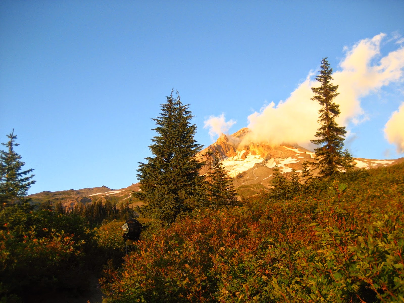
 |
| Three-fingered Jack |
And so we hitched back to Santiam Pass for the second time in a row in the mid day heat. This time, we didn't even get to the edge of town before a girl pulled over to offer us a ride. She was an 2012 AT thruhiker named Slug who was living in Bend now, and offered us oranges and apples, "I know how much you miss fresh fruit when you're out there." At the trailhead, we ran into a young man wearing a canvas pack with a tin can and spring affixed to the outside. His hiking stick had a sharpened rock tied on one end, making it a primitive spear. "Bet that makes hitching harder," I whispered to Craig. He was clearly on some kind of survivalist mission.

We started up the hill towards Three-Fingered Jack, the first peak north. Our packs felt heavy, despite the fact that we only had three days' worth of food on our backs. The only problem with slackpacking is the day after. It was hot too, and the climb was exposed from a previous forest fire. We moved slowly, and I stopped often to take photos and soak in the vistas. Three-Fingered Jack consisted of a row of jagged peaks, with a steep drop off on the north side. We descended only as far as the first water source, Koko Lake, a small pond, and set up camp. A few others trickled in to camp, nodding politely to us. I miss our friends; there are so many thruhikers in the herd, but it still seems to feel more lonely up here in the pack.

We get a late start the next day, but we aren't in a hurry anymore. We have until tomorrow afternoon to get to Olallie Lake, 36 trail miles away. I pick huckleberries by the lake in the morning, bold deer eating them too, eyeing me but still moving closer. The views are beautiful, as we climb between Jack and the next peak of consequence, Jefferson. Part of it has been scarred by fires past, but the naked trees standing like telephone poles make it look like a post-apocalyptic world. I pretend we're characters in The Road, escaping roving bands of criminals and searching for discarded canned goods in cellars.
 |
| Mt Jefferson |
A little while later, I find a pair of full sized scissors on the side of the trail. Who would bring these into the woods?, I think. Nonetheless, I pack them out. No sense in leaving them on the trail. The trail hugs the ridges around Mt Jefferson, taking us into lush valleys with ferns and moss and glacial streams, milky with silk. We stop at a clear lake to have lunch. A section hiker is hanging out too, and we talk for a while. The survivalist dude walks up and joins us. We compare foot callous cracks; his are even worse than mine. Joking, I ask them if they've lost a pair of scissors. "Oh great, you found my scissors!" Exclaims the survivalist. "Now I can cut the felt that I found in that abandoned cabin." I have no idea what he's talking about, but gladly pass off the scissors.

We had only 18 miles remaining to get to Olallie Lake, where we'd planned to meet with my parents the next afternoon. We hugged the north side of Jefferson for the morning. I love the north sides of mountains...they are wetter and lusher, since the sun prefers the south side of the sky in this hemisphere. We cruised through Jefferson Park, with its meadows of wild flowers and weekend backpackers and dozens of lakes.


On our final descent into Olallie Lake, we ran into my dad, who had hiked up to meet us. We all walked down to the lake to meet with my mom and swim in the lake. We spent the night in the nearby town of Detroit, eating Hawaiian pizza and showering and sleeping in a real bed.
 |
| Visit from my parents! Sisters in the background |
 |
| Obsidian Flats |
We passed dozens of thruhikers heading north, most of whom probably assumed we were day hikers like all of the others. We recognized quite a few faces from the Saufleys and areas farther south on the trail. We even ran into Tori and her boyfriend Parker. We had seen them in Tahoe, and hadn't expected to see them again since they were only planning on traveling as far as Crater Lake. The fires had driven them farther north, like all of us. Tori was one of my undergrad assistants in Syracuse, and it was really fun to see her out here doing things other than measuring dead earthworms under a microscope. We gave them our extra sandwich supplies: sourdough, salami, and cheese and hiked on towards Elk Lake. I wanted to do more trail magic on our slackpack, but I can't think of a better recipient of our sandwiches!

 We didn't start hiking until noon, spending the morning packing, breakfasting, and blackberry picking in Detroit before braving the windy, gravel road back to Olallie. I had miscalculated how many miles we had from Olallie to Timberline Lodge, at the tree line of Mount Hood. So we set off quickly, and luckily the terrain was easy rolling hills paved with pine needles. We only stopped for peanut butter and jelly sandwiches, nighthiking for as long as we could. Despite starting at noon, we managed to finish over 27 miles before falling asleep on a carpet of moss. The next day, we hiked up and down hills, occasionally given views of the giant Mount Hood looming to the north. We had planned to meet my parents at Timberline Lodge at 5 pm, but were running short on time, so changed out rendezvous point to the highway at Barlow Pass. While we were waiting for them to arrive, a car swooped up and a guy jumped out. "You guys want a beer?" He asked, pulling two hoppy local cans from a cooler. "Thanks!" we called, amazed at our luck as he pulled away.
We stayed in the town of Government Camp that night at a hotel with a hot tub and warm cookies in the lobby for guests. All around were groups of runners in matching t-shirts, getting organized for the annual Hood to Coast relay race, which started the next morning. Instead of joining the crowds on Mount Hood in the morning, we drove north to Cascade Locks, to hike south for a couple days. I had heard such great things about the spectacular Eagle Creek Trail, that I wanted my parents to hike part of it before they left for home the next day. They dropped me and Craig in town and drove towards that trailhead. We had to hike from the Bridge of the Gods in Cascade Locks to tie together our linear hike, and I figured a 3 mile head start would be a good idea.
The hike from Cascade Locks was just a walk on a bike path, lined with bushes of ripe blackberries, huge, juicy, and sweet. After a little mishap that might have involved some extra hiking up a steep hill, we found our way to the Eagle Creek trailhead. Tons of dayhikers were climbing up the gorge with us; it was a Friday, after all, and we were a half an hour from the Portland metro. We ran into my mom soon, hiking back from the first waterfall, where we hugged goodbye.
 |
| Tunnel Falls, Eagle Creek Trail |

 Past the cliffs, we began our climb in earnest. Hiking south from Cascade Locks to Mount Hood was not, in retrospect, the easiest choice. Cascade Locks is the lowest point on the PCT, and Timberline Lodge is 6000 feet higher. To connect the alternate route from Eagle Creek to the official PCT, we would have to climb the Indian Springs Trail, up 2000 feet in 2 miles, far steeper than anything else on the trail. We stopped after the first tenth of a mile, and ate all of our snacks for the next day and a half in one fell swoop. Eventually we completed the climb, popping out in an abandoned campground. Forest, Hopscotch, BFF, Park, others were there for the night. "Where are you coming from this time?" They asked, confused, and offered us a handful of M&Ms.
We camped in a little grove of trees, only 15 miles into our day but tired from the climb. The next morning, we continued south towards Timberline Lodge. It was 30 miles away, and there were a few big climbs between us and the lodge, but we wanted to get close enough to make it but 7:30 the next morning for the $15 AYCE (all you can eat) breakfast buffet. We were going to destroy that buffet. The closer we got to Mount Hood, the more beautiful the trail became. We began to pass glacial streams white with silt and the ground became a spongy carpet of mosses I could identify by name. Rhytidiadelphus, Hylocomiun, Ptilium, Dicranum like little green friends.

 |
| Picking berries on the climb to Mt Hood |
 |
| Descent from Mt Hood |
Ten minutes at the road, and a car full of things pulled over to pick us up, driven by a friendly deadhead. All was going well until the car shut down. We coasted to the shoulder and he popped the hood. Liquids were full, and nothing was leaking. "Maybe it's the starter," suggested Craig. So the two of us began to push the car, and it roared to life! We leapt inside, once again on our way! One ride, ten more minutes of waiting, and we were back in Cascade Locks, completing our very very complicated week of playing leap frog.
No comments:
Post a Comment